| CLARIFY is a collaborative project between the Universities of Exeter, Oxford, Manchester, Leeds and Reading, and is funded by both the Met Office and the Natural Environmental Research Council. Broadly, CLARIFY aims to improve the representation of model estimates for the direct, semi-direct and indirect radiative forcings of biomass burning aerosols, improve our knowledge of microphysical processes and properties of stratocumulus cloud, challenge and validate satellite retrievals of cloud and aerosol properties, and improve global and regional numerical models for climate and weather prediction. |
 |
| Project Background The most recent Intergovernmental Panel on Climate Change Report 20131 report emphasizes that the interaction of aerosols with clouds and radiation remains the largest uncertainty within Global Climate Models, limiting the accuracy of future climate predictions. In particular, the interactions of light absorbing carbonaceous aerosol particles with solar and terrestrial radiation, and the effect they have in modifying the albedo and lifetime of clouds, are characterized poorly. Moreover, owing to the high localization of aerosol concentrations close to their sources, the impact of increased emissions can have marked impacts on regional weather and climate. |
|
| During the southern Africa winter dry season (June – August), large quantities of biomass burning aerosol (BBA) are emitted from sources that include the burning of savanna, agricultural waste and domestic biofuels. In fact, the African continent is the largest global source of BBA, currently contributing 50% to global emissions.2 Moreover, the anticyclonic circulation that is dominant during the dry season transports these emissions from southern Africa to the South East (SE) Atlantic, where stratocumulus clouds are co-located. Therefore, the SE Atlantic provides a natural laboratory to study the full suite of interactions between BBA, cloud and radiation. The figure to the right shows the region of the SE Atlantic off the coast of Namibia, where there is co-location of cloud and high aerosol loading (measured using the MODIS satellite) allowing aerosol-cloud-radiation interactions to be studied. In addition, there are regions where aerosol-radiation and cloud-radiation interactions can be characterized. | 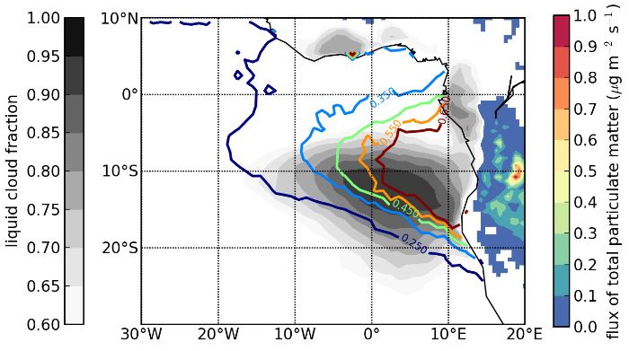 Figure 1: Coloured contour lines – MODIS 2003-2011 mean Aug-Oct aerosol optical depths (AOD); Grey (filled) contours – MODIS cloud fraction; Coloured regions over land – estimates of aerosol emission rates from GFID database. KEY POINT – Strong aerosol-cloud-radiation interactions over the SE Atlantic |
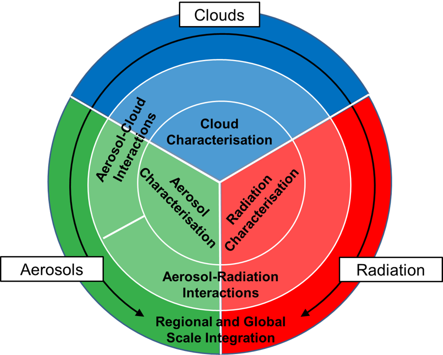 Figure 2: The CLARIFY project consists of characterization of cloud, aerosol and radiation over the SE Atlantic, so quantifying the aerosol-cloud and aerosol-radiation interactions. The overarching goal is to improve regional and global climate models. |
The CLARIFY Project Cloud-Aerosol-Radiation Interactions and Forcing for Year 2017 (CLARIFY 2017) is a collaborative project involving five UK universities and the UK Met Office, working in synergy with other international projects based in the US and Europe (see participants). A team of approx. 50 scientists and engineers from the partner institutions will be deployed to Namibia in August 2017 (during the southern Africa dry season) to study the interactions between aerosol, cloud and radiation over the SE Atlantic. A combination of measurements using in situ airborne and ground based instrumentation, in tandem with satellite observations, will be used to test and validate a range of climate models (including high time resolution / low scale models in addition to global climate models such as HadGEM3). The schematic in Figure 2 (right) summarises the aims of CLARIFY. Principle to the project are fundamental measurements of aerosol optical and thermodynamic properties (green), cloud microphysical structure and dynamics (blue), and spectrally-resolved radiance and irradiance measurements for radiative transfer calculations (red) – including measurements of humidity, temperature and ozone. This comprehensive suite of measurements allows aerosol-cloud and aerosol-radiation interactions to be quantified and, ultimately, the refinement of climate models. Read more in Science and Project Aims |
| Methodology The project will involve deployment of the FAAM BAe-146 aircraft to Namibia for 4 weeks during August 2017. The FAAM BAe-146 is a research platform supported by the Met Office and the Natural Environmental Research Council (NERC) for use by the UK research community. The aircraft contains inlets for sampling atmospheric air and aerosol particles, which are then interrogated by various on-board instruments. These instruments include particle counters and sizers, soot photometers, aerosol mass spectrometers, nephelometers, photoacoustic and cavity ring-down spectrometers, lidar and radiometers. CLARIFY will use these in situ measurements of aerosol and cloud to validate satellite retrievals of aerosol optical depth and single scattering albedo, and help to parameterize and constrain climate model simulations. In addition to the aircraft research platform and satellite data, CLARIFY will employ a variety of ground-based instrumentation such as Doppler lidar, sun photometers and passive deposition traps. Read more in Instrumentation and Sortie Briefs. |
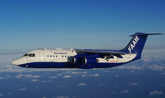 Figure 3: The FAAM BAe-146 aircraft is the research platform that will be deployed to Namibia for airborne measurements of aerosols, clouds and radiation over the SE Atlantic during the CLARIFY field campaign. |